Project Briefing
| lhrNOISEmap | Take Part | Contact | NOISEblog |
|---|
Heathrow Airport handled 481,479 aircraft traffic movements (take offs and landings) in 2007,
by this measure making it the 14th busiest airport in the world. It is situated approximately
20km west of Central London and, although convenient for travellers, its proximity to the city means
that it is surrounded by areas of high population density.
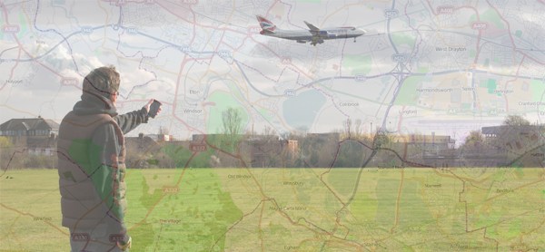
For those living or working near the airport, or under an aircraft flight path, the noise created
by aircraft during take off, landing and in flight can represent a significant annoyance and detriment
to quality of life.
The spatial distribution of aircraft induced noise is represented as contour maps, used by the government
and airport authorities in policy and operational decision making related to aircraft noise. Using data
describing aircraft movements, routes, noise generation and sound propagation contour maps are
created by the Civil Aviation Authority (CAA) using the Airport Noise CONtour computer model, ANCON.
(Down load a printable version of this page here)
(Down load the lhrNOISEmap A4 poster here)
The opportunity - Despite noise pollution being a phenomenon that inevitably affects people at a local level, the
established mechanism for data collection, information distribution and
decision making represents a top down approach in which there is little
public participation, but much public scepticism.
Mobile phones represent ubiquitous and evermore sophisticated devices whose application beyond simple
communication tools are emerging as personal measurement instruments capable of
sensing the environment and empowering collective action through everyday
grassroots citizen science. Leveraging their widespread usage, location awareness and capacity to detect
noise levels, mobile phones have great potential in facilitating a bottom up citizen
driven approach to noise collection.
My aims - By identifying and developing mobile phone technology capable of capturing noise levels, together with an
infrastructure for collating, analysing and visualising this information, the LhrNOISEmap project aims
to use mobile phones to develop a citizen driven model for the
collection of aircraft noise pollution data and the production of noise intensity maps. Engagement with local
communities is key, both in the collection of data and the contribution of
local knowledge and experience.
AudioBoo
and the Audio Map - Initially created as an application for the iphone AudioBoo allows internet users to
share sound recordings in a similar way sites such as YouTube help share video. For the purposes of the
lhrNOISEmap project AudioBoo represents an eloquent means for participants to remotely record and publish
their observations of aircraft noise using their phone. In addition to providing a mechanism for data
collection and communication, by making audio recordings rather
than simple noise level readings (as would a traditional
noise meter) AudioBoo facilitates the creation of an audio map on which markers
represent the location of a sample, which once clicked play a sample of aircraft pollution recorded at
that location.
Noise contour maps - As mentioned the traditional method of representing aircraft noise pollution is by the use of noise
contour maps. With a sufficient number of samples the lhrNOISEmap
project aims to produce a
similar visualization
by quantifying and analysing the level of aircraft noise of the
Audioboo samples submitted for the Audio Map. Presenting this
visualisation as a Noise Contour Layer in addition to the Audio
Layer the resulting map will hopefully result in a useful and powerful tool in helping better understand and communicate experiences of aircraft
noise pollution in the Heathrow area.
All results and analysis resulting from this project will be
made available on the project website, starting with the Audio Map
which is currently in the process of being created.
Ian Tout
| RELATED LINKS | Aircraft Noise | Thanks to the services of... | Birkbeck College |
|---|---|---|---|
| Defra: Airport noise maps | OpenStreetMap | GISc at Birkbeck | |
| DfT: Aviation | AudioBoo | MapSquid | |
| CAA: Environmental Issues | Apple App Store | Geo-Hughes | |
| HACAN ClearSkies | SoundManager2 | ||
| BAA Heathrow: Noise |